Understanding Inversion Layers: A Beginner’s Guide
Inversion layers occur when a layer of warm air traps pollutants close to the ground, preventing them from escaping into the upper atmosphere. This phenomenon can lead to poor air quality, as pollutants accumulate and remain concentrated in the lower atmosphere where humans and wildlife live. These conditions can be particularly severe in urban areas with high levels of industrial activity. Understanding the basic principles behind inversion layers is crucial for both professionals in environmental science and the general populace. By recognizing the signs of an inversion and implementing strategies to reduce emissions, communities can mitigate some of the adverse effects associated with these atmospheric conditions.
The Science Behind Temperature Inversions
Temperature inversions are meteorological phenomena where the normal temperature gradient is reversed, resulting in a stable layer of air that inhibits vertical mixing. In simple terms, a typical atmospheric condition has cooler air near the surface and warmer air above. However, during an inversion, the situation is inverted, causing warm air to trap cooler air below it. This setup is stabilized due to the difference in temperatures, which prevents air masses from circulating and dispersing pollutants. As a result, understanding the science of inversions is essential for comprehending their impact on local and regional air quality.
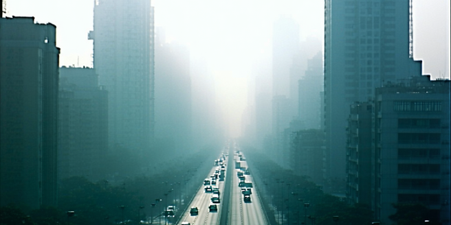
How Inversion Layers Affect Air Pollution
Inversion layers have a significant impact on air pollution by trapping pollutants close to the ground. When an inversion layer forms, the movement of air is restricted, leading to an accumulation of pollutants such as vehicle emissions, industrial discharges, and dust within the affected region. This phenomenon can result in visibly hazy skies and reduced visibility. Since the pollutants cannot disperse upwards, they remain concentrated at ground level, degrading air quality and posing health risks to the population. Monitoring and predicting inversion events are vital for managing and mitigating pollution, especially in urban areas prone to recurring inversion conditions.
Health Impacts of Poor Air Quality During Inversions
The health consequences of poor air quality during inversion layers can be severe, affecting people of all ages but particularly the young, elderly, and those with pre-existing respiratory conditions. One major concern is the increased risk of respiratory infections during such events. Inverted air layers exacerbate air pollution by concentrating harmful particles and gases, such as nitrogen dioxide, sulfur dioxide, and fine particulate matter, which can aggravate asthma, bronchitis, and other lung diseases. Prolonged exposure is also linked to cardiovascular issues. Public health advisories often recommend reducing outdoor activities during these periods to minimize exposure and protect vulnerable populations from adverse effects.
Mitigating Air Quality Issues in Inversion-Prone Areas
Addressing air quality issues in regions prone to inversion layers requires a multi-faceted approach. Implementing stricter emissions standards for vehicles and industries can reduce the overall pollutant load. Public awareness campaigns are essential to educate citizens on reducing their carbon footprint. Encouraging public transportation and the use of clean energy sources are also effective strategies. Urban planning can play a role by integrating green spaces and promoting infrastructures that do not contribute significantly to air pollution. Local governments and communities need to work together to adopt policies that minimize emissions and improve air monitoring systems to provide timely alerts during potential inversion events.
Forecasting Inversion Layers: Tools and Techniques
Forecasting inversion layers involves using a combination of meteorological data, satellite imagery, and computer models to predict atmospheric conditions that can lead to inversions. Advanced weather prediction models help identify potential inversion scenarios, allowing cities to take preemptive actions to mitigate air pollution impacts. These models require continuous input data for precise results. Tools like radiosondes and LIDAR systems measure vertical temperature profiles and atmospheric particles, respectively. By leveraging these technologies, meteorologists can provide accurate forecasts, enabling public authorities to issue warnings and advisories, helping reduce the exposure of populations to harmful air conditions.