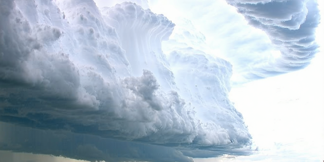
Understanding Thunderstorm Formation
Thunderstorm formation begins with moisture, unstable air, and a lifting mechanism to initiate upward motion. Surface heating, the ascent of warm air, creates instability. Rising warm air cools and condenses, forming clouds. As the process continues, moisture condenses into water droplets, forming cumulonimbus clouds. These clouds can reach immense heights, fueled by the continuous updraft, increasing instability. The intricate dance between atmospheric elements is fascinating to observe. Once conditions are optimal, the cumulonimbus cloud becomes a full-fledged thunderstorm, exhibiting powerful updrafts and downdrafts. Understanding this dynamic cycle is crucial for comprehending storm dynamics and forecasting severe weather phenomena. Meteorologists leverage this knowledge to anticipate storm development, utilizing technological tools for observation and prediction, ensuring safety and readiness for potentially hazardous situations.
Components of Wind Patterns in Storms
Wind patterns within thunderstorms comprise complex components, crucially influencing storm dynamics. Updrafts in the storm’s core contribute significantly to thunderstorm development, carrying warm, moist air upwards. Downdrafts follow, bringing cooler air towards the surface, creating a cycle that sustains storm intensity. The interaction between upper-level winds and low-level inflow shapes the horizontal wind profile, with shear being a vital factor. Wind shear, the change in wind velocity and direction with altitude, plays a pivotal role in severe thunderstorms’ organization and longevity. Additionally, gust fronts, formed by downdrafts, spread horizontally upon reaching the surface, causing abrupt wind changes and temperature drops. Understanding these components allows meteorologists to predict storm development and severity, which is essential for public safety and operational planning.
Technology Used in Wind Pattern Analysis
Advanced technology is pivotal in analyzing wind patterns in thunderstorms. Weather radars, particularly Doppler radars, are instrumental in detecting wind velocity and precipitation within storms. They provide detailed radar imagery, illustrating the storm’s internal structure, allowing meteorologists to identify rotation and possible tornado formation. Additionally, weather satellites play a crucial role, offering large-scale views of storm systems, capturing cloud patterns, and monitoring storm evolution. High-resolution numerical weather prediction models simulate wind patterns, providing forecasts of thunderstorm development and track. Ground-based weather stations, equipped with anemometers and barometers, contribute real-time data for accurate analyses. Moreover, research aircraft fly into thunderstorms, gathering direct measurements of wind velocities, temperature, and pressure. These technologies collectively enhance our understanding of thunderstorm dynamics and improve predictive capabilities for severe weather events.
Impact of Wind Patterns on Weather Prediction
Wind patterns within thunderstorms significantly influence weather prediction, determining storm paths and intensity. Accurate predictions are reliant on understanding the interplay between wind shear, updrafts, and downdrafts, as these elements dictate thunderstorm behavior. Meteorologists utilize wind pattern data to assess the risk of severe weather occurrences like tornadoes, hail, and damaging winds. Precise wind forecasts enable timely warnings, reducing threats to life and property. Understanding surface wind gusts assists in predicting ground-level impacts, critical for aviation and transportation sectors. Furthermore, wind patterns can indicate potential flash flood risks by affecting precipitation distribution. Advances in meteorological technology, coupled with extensive data analysis, enhance the ability to forecast weather changes effectively, highlighting the significance of wind patterns in developing comprehensive and reliable weather predictions.
Case Studies: Real-Life Thunderstorm Wind Patterns
Case studies of real-life thunderstorms offer valuable insights into wind pattern dynamics and their broader atmospheric implications. For instance, the 2011 Joplin tornado showcased how intense wind shear contributed to the storm’s unprecedented severity. Data collected revealed complex interactions between updrafts and downdrafts, elucidating the tornado’s destructive power. Another example is the supercell thunderstorms in Tornado Alley, where detailed analysis of wind patterns has improved understanding of storm rotation and longevity. By studying these events, meteorologists have refined models, enhancing predictions for similar future storms. Case studies also demonstrate how surface wind patterns, influenced by gust fronts, affect temperature and pressure changes, causing further storm developments or dissipation. Through systematic examination of past events, forecasts become more accurate, bolstering community preparedness and response strategies against severe weather threats.